Fantasy Football - Footballguys Forums
You are using an out of date browser. It may not display this or other websites correctly.
You should upgrade or use an alternative browser.
You should upgrade or use an alternative browser.
Official 2023 Atlantic Hurricane Thread - Tammy (2 Viewers)
- Thread starter Mjolnirs
- Start date
The Commish
Footballguy
Already shrunk to TD
Nathan R. Jessep
Footballguy
Was just coming to post this one too. Will almost certainly be Hurricane Lee (Leigh?) by Thursday. Almost all models and spaghetti paths showing no US landfall but an offshore bend towards Novia Scotia where a trough coming from US land side would effective "swat" Lee back out to sea. If that trough were to miss the meeting, Lee could make a landfall. There was one of the early path models showing south Florida landfall.
Senor Schmutzig
Footballguy
I vote "no" on that one.There was one of the early path models showing south Florida landfall.
beer 30
Footballguy
Seems like a weather guy trying to flex on us stupid folk
Wingnut
Footballguy
Anyone wonder what a Cat 5 hurricane hitting Tampa Bay would look like? This is scary.
Project Phoenix:

 youtu.be
Phoenix 2.0:
 youtu.be
Project Phoenix:
Category 5 "Hurricane Phoenix" hits Tampa Bay (worst case disaster scenario)
Hurricane Phoenix: The Tampa Bay Region's Worst Case Scenario. An eye-opening & frightening look at the potential effects of a catastrophic Category 5 hurri...
youtu.be
Phoenix 2.0:
Project Phoenix 2.0: The Recovery
Project Phoenix 2.0: The Recovery is a facilitated training exercise that examines critical issues and capabilities of Tampa Bay area small businesses and em...
youtu.be
3C's
Footballguy
I'm not a pro (he is) but I agree. I don't think it's going to turn north as quickly as the long range models are saying.Seems like a weather guy trying to flex on us stupid folk
But wxrisk doesn't agree so there's that.

Senor Schmutzig
Footballguy
It just goes to show that you don't know who to listen to at this point. I'm looking at multiple sources and just assuming that there is always a chance of this one hitting South Florida.
culdeus
Footballguy
I'm not a pro (he is) but I agree. I don't think it's going to turn north as quickly as the long range models are saying.Seems like a weather guy trying to flex on us stupid folk
But wxrisk doesn't agree so there's that.
One of the things about climate change that was predicted is that stronger storms tend to take themselves poleward more, and eventually something major would hit between DC and Boston causing untold damage.
3C's
Footballguy
Yeah, it seems somewhat likely that this one will "impact" New England and/or Nova Scotia. Trying to choose my words carefully there. Way too early to tell though of course.I'm not a pro (he is) but I agree. I don't think it's going to turn north as quickly as the long range models are saying.Seems like a weather guy trying to flex on us stupid folk
But wxrisk doesn't agree so there's that.
One of the things about climate change that was predicted is that stronger storms tend to take themselves poleward more, and eventually something major would hit between DC and Boston causing untold damage.
NHC bumped the wind speed forecast up to 150mph and it's still likely low.
3C's
Footballguy
Somewhat touches on that: https://twitter.com/EricBlake12/status/1699368019657453611I'm not a pro (he is) but I agree. I don't think it's going to turn north as quickly as the long range models are saying.Seems like a weather guy trying to flex on us stupid folk
But wxrisk doesn't agree so there's that.
One of the things about climate change that was predicted is that stronger storms tend to take themselves poleward more, and eventually something major would hit between DC and Boston causing untold damage.
culdeus
Footballguy
Well, hotter water for sure but stronger storms themselves tend to just go poleward as they "feel" Eastern steering more for their size.Somewhat touches on that: https://twitter.com/EricBlake12/status/1699368019657453611I'm not a pro (he is) but I agree. I don't think it's going to turn north as quickly as the long range models are saying.Seems like a weather guy trying to flex on us stupid folk
But wxrisk doesn't agree so there's that.
One of the things about climate change that was predicted is that stronger storms tend to take themselves poleward more, and eventually something major would hit between DC and Boston causing untold damage.
End result is a big storm that might otherwise go for Miami as a 4-5, instead turns towards times square as a 2-3 where they are much less prepared.
3C's
Footballguy
Warmer waters, rapid intensification, stronger storms, and on and on.Well, hotter water for sure but stronger storms themselves tend to just go poleward as they "feel" Eastern steering more for their size.Somewhat touches on that: https://twitter.com/EricBlake12/status/1699368019657453611I'm not a pro (he is) but I agree. I don't think it's going to turn north as quickly as the long range models are saying.Seems like a weather guy trying to flex on us stupid folk
But wxrisk doesn't agree so there's that.
One of the things about climate change that was predicted is that stronger storms tend to take themselves poleward more, and eventually something major would hit between DC and Boston causing untold damage.
End result is a big storm that might otherwise go for Miami as a 4-5, instead turns towards times square as a 2-3 where they are much less prepared.
PIK95
Footballguy
Halifax was my favorite place I ever visited. Super nice people, and a beautiful spot. I saw Arcade Fire there also. Good times.Worried about Nova Scotia. I’m going there next month.
3C's
Footballguy
Brad is always solid for info. https://www.youtube.com/watch?v=fl4ZO1lWmiI
3C's
Footballguy
Haven't seen the 12z HAFS myself but this is downright crazy if true. https://twitter.com/MeteoAtlas/status/1699480336298561743
ETA: that's HAFS-B which seems to be a little more "aggressive" than A. A looks strong too though.
ETA: that's HAFS-B which seems to be a little more "aggressive" than A. A looks strong too though.
Last edited:
The Big Donkey
Footballguy
Time for some Levi videos
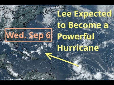
[Wednesday] Lee Expected to Track North of the Caribbean as a Powerful Hurricane
Website: https://www.tropicaltidbits.com/You can support Tropical Tidbits on Patreon: https://www.patreon.com/bePatron?c=651594Follow my Twitter for more fre...
www.youtube.com
3C's
Footballguy
Guess we'll see how these newfangled things do. I'm not worried. 
culdeus
Footballguy
Grahamburn
Footballguy
I don't know what it would be, but you'd think they'd do something to prepare.If we ever do get that direct hit we are screwed.The flooding is worrisome in low lying areas of Pinellas County…St Pete/Clearwater…they can’t take it much higher and high tide is still coming later. Water up to garages on Clearwater Beach north end.
Gawain
Footballguy
Yes, but that's 160 scaring fish. The 5-Day already has it receding a bit to 140 and still not threatening land. Possibility of blowing itself out over open water, which is definitely for the best.NHC bumped the intensity forecast up to 160mph.
FORECAST POSITIONS AND MAX WINDS
INIT 07/1500Z 16.4N 50.0W 90 KT 105 MPH
12H 08/0000Z 17.1N 51.7W 115 KT 130 MPH
24H 08/1200Z 18.2N 54.0W 130 KT 150 MPH
36H 09/0000Z 19.2N 56.1W 140 KT 160 MPH
48H 09/1200Z 20.1N 58.1W 140 KT 160 MPH
60H 10/0000Z 20.9N 59.8W 135 KT 155 MPH
72H 10/1200Z 21.5N 61.2W 135 KT 155 MPH
96H 11/1200Z 22.6N 63.7W 125 KT 145 MPH
120H 12/1200Z 23.6N 66.0W 120 KT 140 MPH
3C's
Footballguy
Right, storms don't stay at cat 5 long typically. If it threatens land it will (should) be at much less intensity. Going to hit some cooler water churned up by the previous 2 storms, if it doesn't stall and do it itself.Yes, but that's 160 scaring fish. The 5-Day already has it receding a bit to 140 and still not threatening land. Possibility of blowing itself out over open water, which is definitely for the best.NHC bumped the intensity forecast up to 160mph.
FORECAST POSITIONS AND MAX WINDS
INIT 07/1500Z 16.4N 50.0W 90 KT 105 MPH
12H 08/0000Z 17.1N 51.7W 115 KT 130 MPH
24H 08/1200Z 18.2N 54.0W 130 KT 150 MPH
36H 09/0000Z 19.2N 56.1W 140 KT 160 MPH
48H 09/1200Z 20.1N 58.1W 140 KT 160 MPH
60H 10/0000Z 20.9N 59.8W 135 KT 155 MPH
72H 10/1200Z 21.5N 61.2W 135 KT 155 MPH
96H 11/1200Z 22.6N 63.7W 125 KT 145 MPH
120H 12/1200Z 23.6N 66.0W 120 KT 140 MPH
The point of pointing out the 160mph is how quickly it's getting there. From an invest to TS to major major (not just major) hurricane in barely 2 days is crazy.
Senor Schmutzig
Footballguy
Both of the HAFS models have Lee reaching 160+ knots within 24 hours.Then intensity goes up and down a bit from there, never back to that strong though.
Why won't it get any stronger with as much warm water as it's going over? Is there a scientific anomaly happening that won't allow it to get any stronger than that? Does it just tear itself up? Or could we see a 200 mph hurricane at some point?
culdeus
Footballguy
Nhc has said in nearly every advisory they are behind the models.
culdeus
Footballguy
Hurricane north of 25 degrees sees quite a bit of mid level shear which mitigates a lot of other formation needs.Both of the HAFS models have Lee reaching 160+ knots within 24 hours.
Why won't it get any stronger with as much warm water as it's going over? Is there a scientific anomaly happening that won't allow it to get any stronger than that? Does it just tear itself up? Or could we see a 200 mph hurricane at some point?
3C's
Footballguy
Besides what culdeus said, there's some cooler water from previous storms, eyewall replacements, etc.Both of the HAFS models have Lee reaching 160+ knots within 24 hours.
Why won't it get any stronger with as much warm water as it's going over? Is there a scientific anomaly happening that won't allow it to get any stronger than that? Does it just tear itself up? Or could we see a 200 mph hurricane at some point?
3C's
Footballguy
Not sure what you mean. That tweet (yeah it's a tweet, not an X) is pointing out that from 12z today +36 hours NHC forecast has it at Cat 5, which is unprecedented.Nhc has said in nearly every advisory they are behind the models.
Senor Schmutzig
Footballguy
So technically it's possible to get up to 200 mph if there were no physical limitations like what will be impacting Lee?Besides what culdeus said, there's some cooler water from previous storms, eyewall replacements, etc.Both of the HAFS models have Lee reaching 160+ knots within 24 hours.
Why won't it get any stronger with as much warm water as it's going over? Is there a scientific anomaly happening that won't allow it to get any stronger than that? Does it just tear itself up? Or could we see a 200 mph hurricane at some point?
Yeah, that would suck if that's the case.
3C's
Footballguy
HAFS-B actually has it reaching about 200mph tomorrow but I doubt that will happen. Even if it does it's out in open water where it can't really hurt anything.So technically it's possible to get up to 200 mph if there were no physical limitations like what will be impacting Lee?Besides what culdeus said, there's some cooler water from previous storms, eyewall replacements, etc.Both of the HAFS models have Lee reaching 160+ knots within 24 hours.
Why won't it get any stronger with as much warm water as it's going over? Is there a scientific anomaly happening that won't allow it to get any stronger than that? Does it just tear itself up? Or could we see a 200 mph hurricane at some point?
Yeah, that would suck if that's the case.
Dinsy Ejotuz
Footballguy
I think I'd be a lot more worried if I were on Long Island than in the Carolinas at this point.
IMO the takeaway from this thing is that climate change has produced conditions where going from not having a threat at all to a Cat 5 in just a few days will become more common.
If that happened with a landfalling hurricane it would add new problems with preparations and evacuations.
IMO the takeaway from this thing is that climate change has produced conditions where going from not having a threat at all to a Cat 5 in just a few days will become more common.
If that happened with a landfalling hurricane it would add new problems with preparations and evacuations.
3C's
Footballguy
Oh for sure, and if the models and experts have it right even LI and up into NE don't have much worry outside rough surf. Way too early to tell though. OBX is likely okay but not certain. There has been a slight westward trend...I think I'd be a lot more worried if I were on Long Island than in the Carolinas at this point.
Worried about Nova Scotia. I’m going there next month.
 Nova Scotia has been decimated with flooding this year already. What did they do to deserve this?
3C's
Footballguy
Let's just hope that all those saying it's going to miss everything are right. They'd probably still get some wind and water but hopefully nothing worse.Worried about Nova Scotia. I’m going there next month.
3C's
Footballguy
Gotta be cat 3 by now. https://pbs.twimg.com/media/F5cp58bXMAAejOD?format=jpg&name=900x900
culdeus
Footballguy
The nhc has text with each advisory and they have had comments that they felt the numbers they were publishing would be low.Not sure what you mean. That tweet (yeah it's a tweet, not an X) is pointing out that from 12z today +36 hours NHC forecast has it at Cat 5, which is unprecedented.Nhc has said in nearly every advisory they are behind the models.
Similar threads
- Replies
- 3K
- Views
- 112K
- Replies
- 3K
- Views
- 130K
Users who are viewing this thread
Total: 1 (members: 0, guests: 1)